Co-Founded by Bret Love & Mary Gabbett, Green Global Travel is an ecotourism, nature / wildlife conservation & cultural preservation magazine. More about us.
(The following is a guest post by Darcie Connell of Trekity.com, a travel inspiration site. She’s also co-founder of Travel Blogger Academy. Follow Darcie on Twitter at @Trekity. If you’re a travel writer interested in submitting a guest post, email Bret Love at GreenGlobalTravel[at]gmail[dot]com.)
Why It May Be Now Or Never
The Himalayas, the world’s most iconic mountains, gave birth to the highest point on the planet, Mount Everest, just 70 million years ago when the Indian tectonic plate slowly collided with the Eurasian continent.
However, Everest’s famous (not to mention extremely dangerous) mountain climbing trek isn’t your only option.
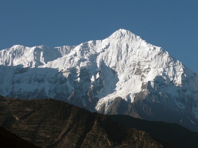
 The Annapurna massif sits quietly in the shadows of Everest and contains six stunning mountain peaks, aptly named Annapurna I, Annapurna II, Annapurna III, Annapurna IV, Gangapurna and Annapurna South.
In September of 2009, my husband Adam and I had the chance to hike the entire Annapurna Circuit. I put emphasis on word entire because we were saddened by the high numbers of tourists who opted to cut their trek short in order to meet their itinerary. More on that in a minute…

The Annapurna Circuit is a horseshoe-shaped route that covers 131 miles (211km) and can last anywhere from 16 to 21 days depending on your walking speed, acclimatization timeline and overall schedule.
The trek begins in the southeastern town of Besisahar at 2,690 feet (820m) and ascends to the highest point, Thorung Pass at 17,769 feet (5,416m). It then descends to Tatopani at 3,937 feet (1,200m) and peaks again for another ascent to Poonhill at 10,499 feet (3,200m). Thereafter it’s all downhill to the final town of NayaPui at 3,510 feet (1,070m). The majority of trekkers hike in this direction, but more adventurous choose the opposite approach.
October, November, April and May are the best months to hike the Annapurna Circuit. The trail is more crowded during this time, but if you get an early start finding accommodations shouldn’t be a problem. While it’s possible to trek in other months (we went in September), be prepared for extreme weather and dangerous trail conditions.
Most trekkers will plan their logistics from Pokhara or Kathmandu. While there, be sure to get an ACA (Annapurna Conservation Area) Trekking Permit and a TIMS (Tourism Information Management System) Card, as they are required for the trek. Transportation to the start of the circuit and porters can be arranged from Pokhara or Kathmandu. However, you don’t need a porter if you pack wisely: Guest houses and restaurants line the entire circuit, so carrying camping gear and food is not required if you stick to the main route.

Most trekkers start the route with a tentative itinerary and figure things out as they go. You’ll want to leave some flexibility for acclimatization, weather and fatigue. The following chart details the Annapurna Circuit, with distances, elevations, lodging options and what we did as a general itinerary. Be sure to give yourself time to acclimatize for a couple days in Manang. There are plenty of accommodations and day hikes to enjoy there.
| City | Kilometers | Miles | Meters | Feet | Lodging | Our Route |
| Besisahar | 0 | 0.0 | 820 | 2,690 | 10+ | |
| Khudi | 7 | 4.3 | 790 | 2,592 | 1-5 | |
| Behulbhule | 9 | 5.6 | 840 | 2,756 | 5-10 | 1 |
| Ngadi | 13 | 8.1 | 890 | 2,920 | 5-10 | |
| Bahundanda | 17 | 10.6 | 1310 | 4,298 | 5-10 | |
| Ghermu | 22 | 13.7 | 1130 | 3,707 | 5-10 | |
| Jagat | 25 | 15.5 | 1300 | 4,265 | 5-10 | 1 |
| Chamche | 29 | 18.0 | 1385 | 4,544 | 1-5 | |
| Tal | 34 | 21.1 | 1700 | 5,577 | 10+ | |
| Karte | 38 | 23.6 | 1870 | 6,135 | 5-10 | 1 |
| Dharapani | 40 | 24.9 | 1900 | 6,234 | 5-10 | |
| Bagarchap | 42 | 26.1 | 2160 | 7,087 | 5-10 | |
| Danaqyu | 44 | 27.3 | 2200 | 7,218 | 5-10 | |
| Latmarang | 48 | 29.8 | 2400 | 7,874 | 1-5 | |
| Thanchowk | 50 | 31.1 | 2570 | 8,432 | 1-5 | |
| Koto | 54 | 33.6 | 2640 | 8,661 | 5-10 | |
| Chame | 56 | 34.8 | 2710 | 8,891 | 10+ | 1 |
| Bhratang | 63 | 39.1 | 2850 | 9,350 | 1-5 | |
| Dhukur Pokharl | 69 | 42.9 | 3240 | 10,630 | 1-5 | |
| Upper Pisang | 71 | 44.1 | 3310 | 10,860 | 5-10 | |
| Ghyaru | 75 | 46.6 | 3730 | 12,238 | 1-5 | |
| Lower Pisang | 74 | 46.0 | 3250 | 10,663 | 10+ | 1 |
| Ngawal | 80 | 49.7 | 3680 | 12,073 | 1-5 | |
| Humde | 82 | 51.0 | 3330 | 10,925 | 10+ | |
| Bhraga | 88 | 54.7 | 3450 | 11,319 | 1-5 | |
| Manang | 90 | 55.9 | 3540 | 11,614 | 10+ | 2 |
| Yak Kharka | 99 | 61.5 | 4050 | 13,287 | 5-10 | |
| Letdar | 100 | 62.1 | 4200 | 13,780 | 1-5 | 1 |
| Thorang Phedi | 105 | 65.2 | 4450 | 14,600 | 1-5 | |
| High Camp | 107 | 66.5 | 4850 | 15,912 | 1-5 | 1 |
| Thorung Pass | 111 | 69.0 | 5416 | 17,769 | 0 | |
| Charabu | 117 | 72.7 | 4230 | 13,878 | 0 | |
| Muktinath | 121 | 75.2 | 3800 | 12,467 | 10+ | 1 |
| Jharkot | 123 | 76.4 | 3550 | 11,647 | 5-10 | |
| Khinga | 125 | 77.7 | 3355 | 11,007 | 1-5 | |
| Kagbeni | 131 | 81.4 | 2800 | 9,186 | 10+ | 1 |
| Eklebhatti | 133 | 82.6 | 2740 | 8,990 | 1-5 | |
| Jomsom | 140 | 87.0 | 2720 | 8,924 | 10+ | |
| Marpha | 146 | 90.7 | 2670 | 8,760 | 10+ | 1 |
| Tukuche | 152 | 94.4 | 2590 | 8,497 | 10+ | |
| Kobang | 155 | 96.3 | 2640 | 8,661 | 1-5 | |
| Larjung | 157 | 97.6 | 2550 | 8,366 | 1-5 | |
| Kokhethanti | 160 | 99.4 | 2525 | 8,284 | 1-5 | |
| Kalopant/Lete | 163 | 101.3 | 2535 | 8,317 | 10+ | |
| Ghasa | 170 | 105.6 | 2010 | 6,594 | 5-10 | 1 |
| Kopchepani | 174 | 108.1 | 1480 | 4,856 | 1-5 | |
| Rusechhahara | 176 | 109.4 | 1500 | 4,921 | 1-5 | |
| Dana | 179 | 111.2 | 1400 | 4,593 | 5-10 | |
| Tatopani | 183 | 113.7 | 1200 | 3,937 | 10+ | |
| Ghara | 188 | 116.8 | 1700 | 5,577 | 1-5 | |
| Sikha | 191 | 118.7 | 1935 | 6,348 | 5-10 | 1 |
| Chitre | 195 | 121.2 | 2350 | 7,710 | 5-10 | |
| Poonhill | 197 | 122.4 | 3200 | 10,499 | 0 | |
| Ghorepani | 200 | 124.3 | 2870 | 9,416 | 10+ | 1 |
| Ulleri | 202 | 125.5 | 2010 | 6,594 | 1-5 | |
| Tikhedunga | 204 | 126.8 | 1500 | 4,921 | 5-10 | 1 |
| Birethanti | 210 | 130.5 | 1025 | 3,363 | 10+ | |
| NayaPui | 211 | 131.1 | 1070 | 3,510 | 1-5 |

From Besisahar, many people chose to take another bus to Khudi to officially start the trek, and some continue up the trail in Jeeps. The first part of the trek meanders along the Marsyangdi River, where you’ll cross several rickety bridges and rice paddies. The terrain is warm and lush, so keep your eyes peeled for leeches.
As you gain elevation, the terrain will slowly change, the air will become thin and dry, and you’ll notice mountain peaks off in the distance, with signs of Tibetan life including prayer wheels, flags and carved stones. Pink buckwheat fields line the lower hill sides.
As you make your way over Thorung Pass, the black lunar landscape crumbles beneath your feet and the sharp wind stings your face. After you take a picture in front of the Thorung Pass sign, you’ll quickly descend down the steep sharp volcanic rocks that lay on the other side. The terrain there is much more dry, rocky and dusty. You’ll move fast on your descent until you reach the hot springs in Tatopani. The terrain will become warm and lush again, which your skin will gladly welcome.
From Tatopani, you’ll ascend another 6,562 feet (2,000m) up to Poonhill, which offers arguably the world’s best sunrise. Thereafter it’s all downhill, including over 3,000 dizzying stone steps. Make sure you have good footing, as falling on those stones is not fun.

The Annapurna Circuit is one of the best hiking treks in the world, but it’s quickly changing with the ever- increasing demand of tourists.
Over the years, more and more tourists have been traveling to Nepal and trying to cut the Annapurna circuit short. To meet their growing demands, roads have been built at the beginning and end of the hike, and are continually being developed. I believe that these roads will eventually cover the entire route. The most notable evidence of this comes shortly after crossing the Thorung Pas, in the town of Jomsom. The trail has developed into a road, where people can take jeeps all the way to the end of the circuit.
While this “progress” might not seem all that terrible, it is for trekkers who want to experience the full beauty and terrain of the Annapurna Circuit on foot. Imagine some of the most beautiful terrain in the world, spoiled by the constant flow of tourist-filled jeeps honking, whizzing by, and kicking up rocks and dust in their wake.
This puts trekkers in a horrible position. The question will unavoidably arise: “Do I continue to deal with the jeeps, or should I simply jump in one?” I have to admit, there were a few times when even I almost cracked.
Does this mean the trek will be destroyed forever? Who knows? However, for now there seems to be an equal demand among those wanting a shorter trek and those wanting a longer trek, and the Nepalese realize there is an opportunity to meet both parties’ needs. While the original Annapurna Circuit might one day be lost to the jeeps, there’s always an opportunity to develop new trails where trekkers can enjoy the area’s gorgeous landscapes in their pristine natural state. –Darcie Connell; photos by Darcie Connell & Adam Costa
If you enjoyed reading Hiking The Annapurna Circuit: Why It May Be Now Or Never, you might also like:
Tanzania- Climbing Mt. Kilimanjaro
Autumn in The North Georgia Mountains
Outdoor Adventures in Wild, Wonderful West Virginia
10 Unbelievable Mountains For Your World Travel Bucket List
Jeeps from Jonsom? That’s outrageous! I don’t remember hearing a single automobile engine for almost three weeks. I was there in 2001 I did the entire circuit (anticlockwise)– easily one of the top 3 things I’ve ever done and seen in my life. Fantastic memories. Your post relived some of that for me, especially the talk of the pass at high altitude and then Tatapani! (However, I recall Muktinath right after the pass, coming down. That was a very special place, too.) Anyway, when I was there I remember how short and simple the fly-in and trek out option seemed — by Jonsom those folk seemed like Sunday picnic crowd! I’m surprised to hear there are actual roads touching any of the main circuit. I enjoyed all of it, but probably the top half most of all. More remote, less traveled, smaller villages.
JPM (LotusArtichoke) recently posted..Palak Tofu Paneer
I totally agree – the best part is the top half. Unfortunately, Jomsom is getting really crowded. What makes it difficult is that many locals are happy about the road because it makes their life easier. It also (probably) brings in more tourist revenue due to easy access.
But at what cost?
What a great article – and so very important. We often ruin the things we love by carelessness. Hopefully this article is a wakeup call.
wandering educators recently posted..4 Best Experiences To Have On Lago de Atitlan
Really interesting! I never knew how long this trek was before. Shame about the tourism ruining the very thing so many come to see…it’s a common theme, unfortunately!
That sounds like an incredible trek. Sadly, the things that are incredible are often the things that are then opened up to pave the way for the masses. Not that people should be denied the opportunity to see the wonders of the world, but I’d hope there would be a less impactful way to do it…
Laurence recently posted..Capture the Colour Photo Contest
If this article has done one thing it’s inspire me to try and get on the track sooner rather than later. I walked some of it as a teenager with a small school group and I still remember it as one of the greatest trips of my life (perhaps because I wasn’t so old and jaded then). I’ve been wanting to go back ever since and this could be the catalyst. Great post – thanks!
Turtle recently posted..How to visit Tuscany cheaply
I’m actually planning to tackle the Annapurna trek in late August. Hoping that the weather will cooperate since I don’t have a choice regarding the timing since we want to bring the kids, and we have to accomodate school schedules.
My husband and I trekked a bit of it in 1990, and it was beautiful, but we didn’t have time to do the whole trek. Of course, the jeep-trodden roads didn’t exist then. I’m concerned about their impact on Annapurna, but I guess I’ll just be grateful to see any of it – without torrential rains – this summer.
Sandra Foyt recently posted..Six Flags Great Escape Theme Park – Fun for the Youngest Thrill Seekers
So Sandra – report on how your trip was… did you have the monsoon rains dampen the trip?
would love to know.
Whoa! Jeeps for the final legs of the Annapurna Circuit? Seriously mixed feelings about that. We expected the circuit to have changed since we trekked it (including the Annapurnna Base Camp spur) in the 90s (an adventure we covered for the now, sadly defunct Escape magazine http://trans-americas.com/work/story%20pdf/Old_Adventure/Escape_Annapurna_04-2000.pdf). BUT JEEPS?
I love to hike and the scenery here is beautiful. Seems like quite a tough trek on the Annapurna circuit. I am not sure if I am ready for this one but it’s hikes like this that make me fall in love with nature all over again.
Jeremy Branham recently posted..9 life lessons I learned as a travel blogger – Travel Confessions Part III
That would be amazing! Always wanted to hike there but just haven’t had the time or money to do it.
Same here! I’m actually a little jealous of Darcie and Adam here…
Beautiful landscape, I’ve been to the Indian Himalayas and loved it. It seems untouched by modernization, unnerving at times, but so fascinating.
Angela recently posted..Video: S’Ardia, running a wild horse race for faith
Ooh, would love to visit the Indian side as well. India is general is near the top of my must-see list. Mary’s been, but I never have…
Bret, if you’ve not been to India, you’ve simply GOT to do Nepal in conjunction with that! See my comment below about the 3+ day overland adventure to Kathmandu from the Indian side (from either Delhi or Varanasi) If you like overland journeys, it’s exhausting but amazing. India’s all hooked up with cheap flights, too (see cleartrip.com, also for any train bookings) but that’s not so green.
Varanasi is one of the most amazing places in the world as almost anyone who’s been there will tell you.
JPM (LotusArtichoke) recently posted..Eggplant Basil Coconut Tofu Curry
I hiked the Annapurna Base Camp route in 2006 and even then it sounded like the Circuit was not the same as it used to be. Tragic to see wilderness encroached upon but difficult to argue with desperately poor Nepal trying to attract bigger spending visitors. I just hope their efforts at development don’t prove short sighted.
It’s such a stunning region and I then went over to the Khumbu and did a 16 day hike there. Would go back to Nepal to do more trekking in a heartbeat.
Natasha von Geldern recently posted..Fiji Isles: Smiles of Savu Savu
Yeah, it’s tough to balance the economic needs of people in developing nations such as Nepal with the need to preserve the pristine nature of their local ecosystem. Hopefully they’ll develop sound ecotourism practices to ensure that the economic benefits of tourism can be sustainable long-term.
I’ve done severel multi day hikes before, but no longer than 4 days. i dont think I could hike for 16 – 20 days!!! My blood pizza levels would probably get too low and I might die

Jade Johnston – OurOyster.com recently posted..Free E Book – The Art Of World Travel
I think a week or so is the longest I’ve done, though I’d have to ask my parents to be sure. They used to take our church youth group camping in the north Georgia mountains a lot when I was a kid, including a memorable trip to the southern part of the Appalachian Trail.
Oh no! I want to do this before it’s ruined.
Stephanie – The Travel Chica recently posted..Punk Tango in Buenos Aires
Us, too! Know anybody offering free/cheap flights to the Himalayas?
The cheapest way to get to Kathmandu is almost always a flight to India (Delhi) and then overnight train to Varanasi and bus to Kathmandu. It takes 3 days but you’ll save about 200-400€. It’s quite an adventure, and you do need to get a visa for India in advance. There might even be a bus from Delhi to Pokhara (Nepal) but it must be grueling… 3 days.
You can also fly to Delhi and then get a cheap flight from there to Kathmandu– this way I believe you could avoid having to get a full tourist visa for India and opt for a transit visa, if necessary. Last I checked flights Delhi-Kathmandu were 70-100+€. (Look on cleartrip.com)
In recent years from Europe to India the cheapest flights have been Turkish Airlines and a few other Middle Eastern (Qatar?) carriers. Most of the European carriers are 100-200+€ for a RT, but it depends on season and specials.
If you hear of any free flights, be sure to tell me first after you’ve booked. Hahaha.
JPM (LotusArtichoke) recently posted..Eggplant Basil Coconut Tofu Curry
Beautiful! One day, I’m going to set aside the three weeks for this.
Sophie recently posted..Powis Castle – A Welsh summer garden
Wonderful post and pics. I can’t believe there’s a road to Jonsom now? I did the Annapurna Sanctuary trek way back in 1983, and even as the shorter option to the Sanctuary, it was so untouched and remote. In 1989 I lived near Mugling for a year, when my hubby was working on the rehabilitation of the Kathmandu to Pokhara highway – I had a five week old baby and we were 45 minutes from the nearest phone, and over an hour from the nearest food market. Life was very simple for us, and I can just remember how remote and inaccessible everything was.
Johanna recently posted..13 Reasons to visit Outback Australia
It is very good blog and appreciate it. Liked the analysis from neutral point of perspective.
Thanks very much! We do try to remain at least somewhat impartial in all of our stories.
We trekked the Annapurna circuit 10 years ago, it took us over 3 weeks as we did it in heavy snow , blizzards held us back for a few days. You certainly don’t need guides or porters, it was a very well worn trail even then. We will be in Nepal next year and I wanted to take the kids some of the way up, I’m not going to risk taking them all the way , I’ve seen what altitude sickness can do. I just wanted them to see what life in the villages up there was like. I guess it’s completely changed now that the road is there, maybe not worth going at all. The local people’s lives must be easier, but it’s bad news for us.
Alyson recently posted..Great Big Fish Meets Two Little Fish : Photo Friday
Sounds like an amazing experience for the kids! We’ve never been to Asia proper, but would love to see Nepal and Tibet someday.
I just did this trek last year and the roadwork on the Manang side extended all the way up to Chamche. By now they’ve probably blasted it up that steep climb into Tal. It really will change the whole experience. It already has changed parts of it, as the walk from Kagbeni to Jomson on the other side of the pass was incredibly annoying with the constant jeep traffic kicking up dust and drowning out any and all natural sounds.
Daniel McBane recently posted..Who Says Trekking in Nepal Has to Involve Lots of Walking?
Pingback: CHILE: The Road To Torres del Paine National ParkGreen Global Travel
Pingback: ANTARCTICA: Mary's Hilarious Freakout During the Polar PlungeGreen Global Travel